Now that we’ve had a dry January so far, we have to get up off our restful recliner that we settled into after the December deluge helped us get so comfy with the drought situation. We’re still comfortable, but seasonal prognoses still indicate a drier than normal January-March period. La Nina is still driving this bus. Daniel Swain helps us get up out of that recliner and look to the future for a minute. https://weatherwest.com/archives/12616
With cautious optimism, experts are beginning to admit that the wet October and December that sandwiched a very dry November, is putting a serious dent in the California drought. The L.A. Times tells the story quite well…
I especially like this quote, which puts the drought depth and recovery into relatable terms: “Not getting paid for three months and then getting a normal paycheck doesn’t put you back to normal in your bank account,” said Noah Diffenbaugh, a climate scientist at Stanford University.
Leave it to a guy named Noah to authoritatively discuss drought, right?
You might initially dismiss that receiving close to normal precipitation is boring. Uneventful. Hapless. But if the last 10 years mostly in severe drought has taught us anything, normal is a blessing. Uncommon. Hopeful.
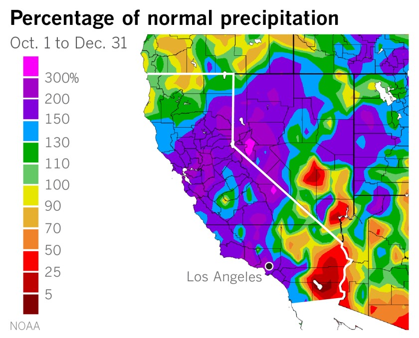
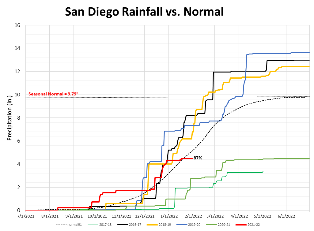
Jan Null of Golden Gate Weather compiled illustrative plots of seasonal precipitation with respect to normal. https://ggweather.com/water/
I love these graphics because they do what graphics are supposed to do: give you a really detailed understanding of something complex, almost for just a glance. It was interesting to note that, in San Diego (shown below), three of the past five years have actually ended up above normal. Bet you didn’t think that. But to compare apples to apples, season to date (by mid December) totals show two seasons above normal, two seasons below normal, and two seasons really close to normal (this season included). Now San Diego hasn’t suffered quite as deeply from lack of rainfall as the rest of California, but there’s reason to not despair.
Last Friday (3 Dec), I wrote the Area Forecast Discussion at the NWS in San Diego. In it, I said,
A continental-scale shift in the weather pattern occurs starting
Monday and Tuesday. Across the western U.S. a series of shortwave
troughs will push southward across the region, taking turns
breaking down the massive, persistent ridge we`ve had along the
West Coast since October. The ridge seems to migrate westward,
essentially opening the door for these shortwaves to give us at
least a chance of precipitation next week. The first wave arrives
late Monday into Tuesday.
Now that it’s Tuesday and we got our first tiny, weak wave. It brought very light rain and was the first step in the breakdown of the ridge over the West. Because of this persistent ridge lasting the entire month of November, places like Denver and Salt Lake City haven’t received measurable snow yet this season, while the higher mountains of Hawaii famously have. Lots of high temperature records have fallen across the northern Rockies region, like the 65 degree reading in Missoula, MT in mid November.
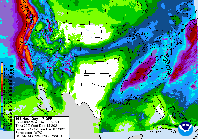
So today the breakdown of the long wave ridge has begun. The next stepping on the ridge happens Thursday, still on track to bring us rain, more significant than today’s. The precipitation amount forecast below was made today, Tuesday 12/7 by the NWS San Diego.
With the strong ridge sufficiently softened, a massive, strong and very wet weather system appears on our model guidance for some significant rainfall all across California next Tuesday or Wednesday (14-15 December) or both days. I’ll let Daniel Swain explain that a little more: https://weatherwest.com/archives/12029
After a record warm and record dry November, get ready for cooler and wetter weather.
GEFS ensemble looping 7-16 December. Note the blue troughs hitting California with greater strength and influence.
The Weather Prediction Center issued their forecast for the upcoming week’s forecast precipitation (below). Note, it only goes out through Tuesday afternoon, 15 Dec. Looks like over an inch is a real possibility in the coming week for most of SoCal.
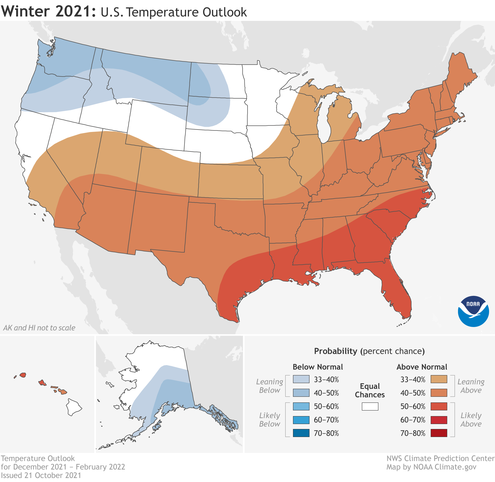
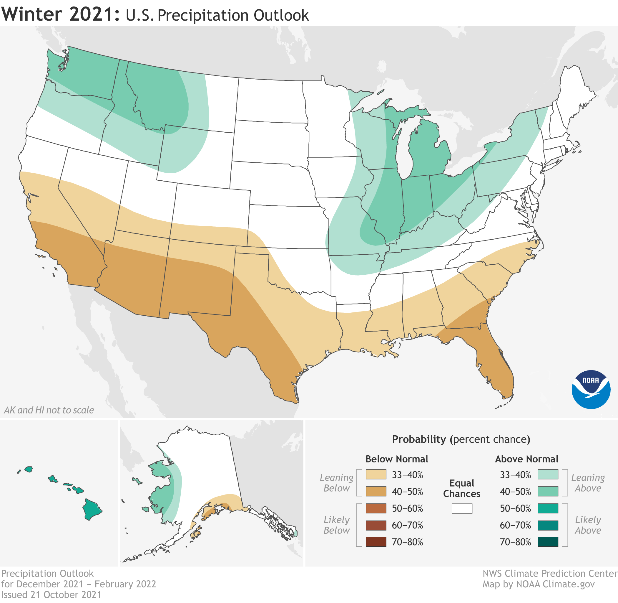
El Nino. La Nina. Opposite ends of the ENSO. They run hot and cold and they are definitely capricious. We think we have some skill to predict long-term weather because of limited success with ENSO projections in the past. Sometimes teasing out a forecast or a long-term outlook out of data is a stretch. Other times I just feel like, “just give me the facts.”
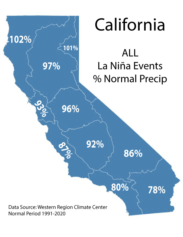
That’s why I appreciate my colleague Jan Null of Golden Gate Weather for crunching the numbers and just stating the facts. We can draw our own conclusion about what La Nina or El Nino will bring (hint: the data isn’t very conclusive most of the time). Jan provided this objective look at ENSO events and their relationship to California rainfall.
With gratitude we recognize that Mother Nature gave California a great gift in October. Tis the season for giving thanks, but this November we’ll have to observe that tradition for the blessing of October. Cuz we ain’t gettin’ no rain in November.
So with mixed emotions I’ll point to climate scientist Daniel Swain with his November update. There’s some good news and some bad news… https://weatherwest.com/archives/11748
As expected, it’s a prediction based heavily on La Nina already present and accounted for. She’s a double-dip La Nina. We had her with us last winter, then she faded, and now she’s back. Despite the dry conditions expected for most of California this winter, we do have a short-term ace up our sleeve. At least NorCal has the ace. It’s an atmospheric river that’s going to drive a boatload of rain into NorCal and CenCal (that’s my cool way to say central California) on Sunday. That same storm will dwindle to an atmospheric trickle by the time it gets into SoCal. Here’s what I wrote in the forecast discussion this afternoon.
You`ve no doubt heard about the strong jet and the
  atmospheric river pouring into northern and central CA. This will
  progress southward Monday morning, but the river will turn into a
  trickle by the time the shortwave stumbles through extreme SoCal.
  From L.A. north it looks like a solid rain. Our numbers for
  rainfall amounts seem to be settling on a consistent solution: 1.0
  to 1.5 inch in San Bernardino Mountains, 0.20-1.0 inch coasts-
  valleys and about 0.15 inch or nearly nothing in deserts. Greater
  rainfall north and lesser south. This remains true after an
  analysis of the latest 12Z guidance.
The rainfall gods are raining down gifts in October(!) upon NorCal and CenCal. Here’s more on that from Daniel Swain, climate scientist at UCLA. https://weatherwest.com/archives/11466
Yes, I know. The headline was too easy, and has been used before. This morning at the NWS I wrote this in the forecast discussion about our extended forecast:
A deep trough of low pressure over the northeast Pacific along with an impressive jet stream shows some promise of significant rain across all of California for next weekend (23-24 Oct). A growing number of ensembles and deterministic models are beginning to lean in that direction.
It’s hard not to get excited about that. Let it rain and end this worrisome fire season before the Santa Anas start in earnest! Let’s put a dent in what is now called Northern California’s worst drought on record! Daniel Swain in his blog explains how this might happen: https://weatherwest.com/archives/11383
Projected 10-day accumulated rainfall from European ensemble mean from 10/15 through 10/25.
This extended forecast comes with the baggage of all extended forecasts… fantasy!! I will say in recent years ensemble forecast suites have made improvements to extended forecasts, at least a way to narrow down the possible scenarios to two or three projected outcomes. Ensembles are helpful because it’s like running 50 models. So meteorologists can look at different scenarios and listen to the voices of a choir over one voice of a soloist.
In the last 20 years, we’ve seen many projections for seasonal rainfall in Southern California largely based on ENSO, the El Nino – Southern Oscillation. The warm phase of ENSO is El Nino. The cool phase of ENSO is La Nina. What happens in the equatorial Pacific Ocean does not stay in the equatorial Pacific. Affects or impacts or repercussions are quite global, with some parts of the world fearing either drought and wildfires or excessive precipitation and flooding damage.
During the 1980s and 1990s, researchers from academia and the federal government’s Climate Prediction Center (CPC) made projections based on the wealth of data and lessons learned from the 1982-1983 El Nino. We’ve got something here. We can make a breakthrough in seasonal precipitation predictability. Before that time, not much thought was given to making credible predictions for seasonal rainfall. A fool’s errand at best. But for about 20 years, we did really have something we learned in the 1980s. We can make predictions and they seem to be helpful. Projections of the major 1997-1998 El Nino and its excessive rainfall in California and elsewhere seemed to go according to plan. Then in the 2000s, the wheels sort of fell off this predictive vehicle.
In 2002-2003 there was a moderate El Nino. Should have a really good chance at above normal rainfall, no? In Southern California that season was among the driest on record.
In 2004-2005 there was a weak El Nino. Maybe a little wetter than average. San Diego recorded its third wettest season on record and a winter full of flooding.
In 2010-2011 there was a strong La Nina. No way we’re getting much rain. In came the above normal rains statewide.
From 2012 through 2016 California endured one of its worst, if not the worst droughts in recorded history. Maybe that moderate La Nina in 2012 really meant something and had lasting impacts through the neutral years that followed.
The tables turned in 2015-2016 as the “Godzilla” El Nino captured headlines. This strongest measured El Nino was supposed to be the biggest slam dunk prediction in our short history of predicting seasonal rainfall. When six out of seven El Nino episodes bring you above normal rainfall in Southern California, what would you predict for the strongest El Nino on record? Yeah, me too. Wet.
It didn’t turn out well. 2015-2016 ended up quite a bit drier in SoCal, wetter in far NorCal, and near normal in central California (CenCal?). A typical El Nino projection turned upside down. See image below. Explaining why the massive bust in that wet projection deserves its own story. The result is that the minor busts earlier in the 2000s leading up to the major bust of 2015-2016 chips away at our confidence that the CPC and others have predictive capability. There are other factors that go into seasonal predictions, but ENSO is the prominent factor and most heavily used in CPC’s calculations.
The resulting precipitation anomaly for the El Nino of 2015-2016.
So, when the CPC begins to trot out their outlooks this time of year, we Californians take notice. Our climate depends nearly completely on the precipitation we get between October and April. If we don’t get precipitation during that time, drought is virtually guaranteed. Exhibit A, the last two winters in California, especially Norcal.
Jan Null, retired NWS forecaster and consulting meteorologist for Golden Gate Weather Services, did a lot of work to illustrate just how finicky these forecasts can be. Check out his easy to use page about ENSO and resulting rainfall and you can draw your own conclusions. https://ggweather.com/enso/october/
My conclusion? It’s the same as Null’s. Caveat Emptor.
CPC’s seasonal outlook for Dec-Jan-Feb (made in mid September) this coming winter reflects what anyone would expect with a weak La Nina projected to persist through winter. Hedging bets toward drier than average. A very safe bet. (CPC’s official winter outlook should be out by October 23, 2021, and should show stronger tilts in either direction). Those of us who want to put a big dent in California’s drought or who just love rainy winters so we don’t have to worry about drought, will root for the kind of La Nina that has given us wetter than normal winters, which we’ve seen a few times in the last 20 years.
It would be great to find more clues we can count on to more helpfully predict seasonal rainfall, like our helpful discoveries with the El Nino of 1982-1983. Brilliant researchers are on the job, but we’re not there yet.
I’m on the public forecast desk at the NWS for a few days and we’re seeing some signs of fall-like weather in California. That’s a double-edged sword and could mean helpful, beneficial rain or Santa Anas that spread wildfires, or both! Far northern California should get some decent rain this weekend, a nice appetizer for what is hopefully a winter wet season feast. That same system will move cold air into the interior West and push offshore flow into SoCal, but today it doesn’t look to bring a true Santa Ana episode with strong winds or super hot weather. Still, it’s an indicator of more of that kind of pattern to come.
Climate scientist Daniel Swain explains this and also goes out on a long-term limb to discuss what kind of wet or dry winter we’ll have in California. With a strengthening La Nina, the odds look more favorable for a drier than normal winter. But odds are odds, and the lesser likely thing (a wet winter?!) is also possible.