The active weather pattern continues. At the NWS office we’re asking each other, “when is it going to stop? I’m so done with it.” There are some things you can’t do outside when its rainy or even drizzly. Today is nice, but things go back into the gray and rainy, stormy regime Tuesday and Wednesday. For northern and central California, it’s not looking favorable to avoid problems or disaster. Daniel Swain of UCLA highlights it for us.
Story about the Book
Want to forecast the weather in San Diego? You’d better have nerves and a sense of humor.

Meteorologist Miguel Miller’s new book explains the nature of everything from Santa Ana winds to “June gloom” and how forecasters predict what will unfold in Southern California.
BY GARY ROBBINS
Years ago, an aquaintance asked Miguel Miller what he did for a living, not long after he had started working at the National Weather Service in San Diego.
“I forecast the weather here,” he said. She quickly replied: “Is this where they send the beginner meteorologists?”
Miller, 55, chuckled at the memory recently before pulling a shift at the weather service office, which is located in Rancho Bernardo, overlooking the mountains.
“It wasn’t an isolated incident, just one of the most overt,” he said. “I wasn’t offended by it.”
But he has never liked the fact that much of the public believes — wrongly — that the weather rarely changes in the San Diego area and that it doesn’t take much to figure out what’s coming next.
Miller has responded by publishing, “The Remarkable Weather of Southern California: It’s Science and Subtleties,” a book that arrives during a winter of record snow, driving rains and some of the strongest winds to hit the coast in years.
It is an easy-to-read, illustrated primer that explains everything from why Santa Ana winds are usually hot to how coastal eddies evolve into some of the prettiest rotational patterns found in nature.
He went further in interviews with the Union-Tribune, talking about how forecasters get many things right and why they sometimes get important things wrong.He especially wants you to know that the region’s weather isn’t the static tableau depicted in movies.
“In the plains states people say, ‘If you don’t like the weather, wait five minutes,’” said Miller. “In Southern California they say, ‘If you don’t like the weather drive somewhere for five minutes.’”
He was alluding to the extraordinary size and geographic diversity of the area covered by the weather service’s San Diego operation.
The office forecasts the weather for all of San Diego and Orange counties, western Riverside County and southwestern San Bernardino County. The region is home to more than 10 million people. Only nine states have as many or more residents.
The topography ranges from the wind-whipped Coachella Valley, much of which is below sea level, to the mild, twisty Pacific coastline, to the San Bernardino Mountains, whose highest point rises to 11,499 feet. Some of its peaks have recorded more than 100 inches of snow this winter. The mountain is a borderline for the Cajon Pass, where bad weather regularly contributes to deadly traffic accidents.In the summer, it’s not unusual for there to be a 45-degree temperature difference between Oceanside and Borrego Springs. And the monsoon can spark intense lightning in East County, which is covered with chaparral, the most flammable type of brush in the country.
“Most people don’t tend to think of the extremes because they live at the coast, in places like San Diego, which gets at least some sun more than 260 days a year,” said Miller, who lives in the Carmel Mountain neighborhood. “But you don’t have to go far inland to experience those extremes.”
The milder weather at the coast also has a distinct and often overlooked impact on daily life. Fewer people go to the beach if the “June gloom” clouds get really thick. That means fewer people rent surfing and diving equipment and fewer file into beach-side restaurants and bars.
The opposite happens when it gets hot and sunny.
“We get calls from the Hotel Del and vendors in La Jolla Cove who want to know just how hot it will be so they can get an idea of how much ice cream they might sell,” Miller said.That’s where most of his interests lay. As he says in his book, “I don’t need tornadoes, hurricanes, thunder, lightning or blizzards to get excited about the weather … I’m just as stimulated by the subtleties.”
His fascination with the weather arose when he was about 11 years old and began using a thermometer to measure the temperature at his home in Mt. Pleasant, Utah, a small town in the central part of the state. This evolved into a deep passion. He earned a degree in meteorology at the University of Utah and, in 1998, landed at the weather service office in San Diego.He’s a nerdy, easy-going guy with a corny sense of humor. He’ll ask people things like, “What happens when the smog goes away in Los Angeles? UCLA.”
But Miller is hyper-focused on forecasting the weather, which involves some challenges that aren’t widely known to the public. He says, for example, that forecasting fog at San Diego International Airport — one of the busiest single-runway airports in the world — can be more difficult than predicting a tornado in Texas or a Nor’ easter in New England.
“When it comes to the airport, you’re calling the weather for one small spot,” Miller said. “And the conditions that lead to fog are very subtle and very sensitive to minor changes in temperature and dew point. A 2 mph difference in the wind and a 30 degree difference in its direction can determine whether you get fog that can shut down the airport.”
It also can be difficult to forecast the path of a large, approaching storm, which became painfully apparent in late February.
The weather service told the public that a system that was drawing extra energy from the subtropics would clobber San Diego County with heavy snow and rain. Forecasters warned people not to venture into the mountains because the snow might cause a white-out. Swift-water rescue crews went on alert.
The storm unexpectedly shifted farther north, delivering a comparatively weak hit locally. The change was missed largely due to the limitations of the numerous computer models used by forecasters.
There was a little bit of indication, late in the cycle, that things were shifting. But Miller said, “We don’t want to latch on to the outlier model that might be detecting something that’s really going to happen.
“It’s like we’ve got 10 solutions and only one of them is saying, ‘Hey, it’s going to slow down, it’s not going to hit San Diego very much.’ We’re not we’re not going to ignore the other nine and go off on the lark of one model.”
The weather service had accurately predicted the two storms that immediately preceded the bigger one. But missing changes like the one that occurred with the biggest system bothers Miller, who said, “I feel bad. I got into the business with the intent and the desire to give people the best forecast.”
The opportunity for redemption is never far away. The weather is always changing.
This weekend, forecasters are tracking a storm that might bring significant rain to the San Diego area on Tuesday.
Miller is focused on that. He’s also hoping that more people come to understand the region’s weather and how forecasts are crafted.
“I’d love to have my book go in the science reference section of college libraries,” said Miller, who spent five years writing the tome. “I also want it to be on library shelves at middle schools, and absolutely in people’s homes.”
More ARs, More Misunderstanding
Here’s an update from Daniel Swain, climate scientist from of UCLA about the atmospheric rivers poised to hit the state in the next couple days and again next week. https://weatherwest.com/archives/24693
But take a look at the last section, where he comments on “A brief reflection on communicating risk to diverse audiences.” We have so much good, accurate information coming together when forecasters need to communicate risk and what’s going to happen, often in probabilistic terms. Unfortunately, so much misinformation and misinterpretation gets into the mix, that people may not take something serious, serious enough.
The Book is on the Market
Back in 2017 when I began work on this book, I didn’t think it would take 5-6 years to complete it and publish it. But here we are! The Remarkable Weather of Southern California: Its Science and Subtleties has been published and is on the market, at least at Amazon. I hope this book finds a home in libraries across the region (and world?) from city and county public libraries, school libraries at all levels, and most hopefully, colleges and universities. Tell your weather geek friends all about it!
A Crazy Forecast
Extreme heat this week will begin to take a back seat to: 1) strong winds and fire danger, 2) downslope extreme warming near the coast and 3) heavy rain possibly leading to flash flooding. It’s a cornucopia of weather these days.
Daniel Swain of UCLA explains all these things pretty well. Check out his blog: https://weatherwest.com/archives/17401
Heat Week
Hot weather will continue this coming week, but you probably already knew that. Daniel Swain of UCLA explains why, and pontificates about the coming month in the temperature and fire weather department. https://weatherwest.com/archives/17179
Benevolent Early Summer Weather
We had a decent heat wave in April, then another one in May. On schedule is what could be our only heat wave in June. They have all lasted only a couple days. In recent years, this level and duration of heat represents a trend downward in intensity and duration of heat waves.
We’ll take it.
With the drought intensifying this winter and spring and the early start to lots of wildfires statewide, we understandably feel a bit worried about the summer and fall with regard to heat and wildfires. Rain in Northern California and few short-duration heat waves has put big wildfires on the back burner. Mother Nature seems to be giving us a little break (current heat wave notwithstanding) or at least delaying the bad stuff. Daniel Swain of UCLA explains these current trends: https://weatherwest.com/archives/15281

Decent Storm, Last Hurrah?
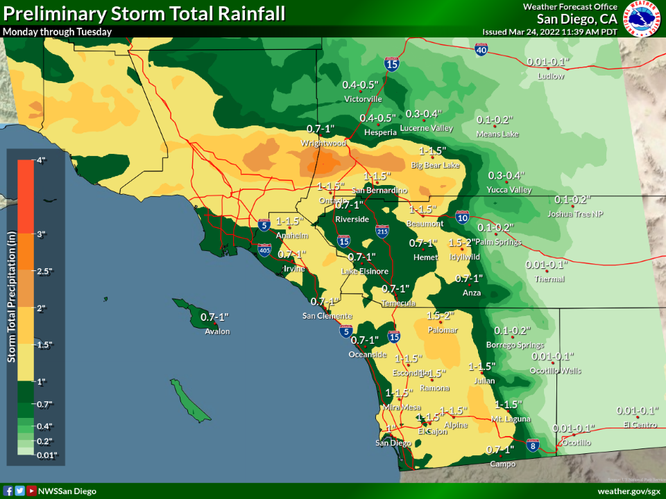
The storm for Monday into Tuesday in SoCal is looking pretty good. At the NWS San Diego, we’re forecasting greater amounts (trending wetter) with seemingly each model run (see the 24 March graphic below for the storm 28-29 March). That’s all well and good, and we can sing in the rain for a day or two. But we are moving swiftly out of the wet season, certainly out of the Sierra snow season, and the prospects for more winter storms are evaporating. Proportionally, we’re on a collision course for severe or extreme drought.
The spring outlook doesn’t look great. Climate scientist Daniel Swain explains. https://weatherwest.com/archives/13823
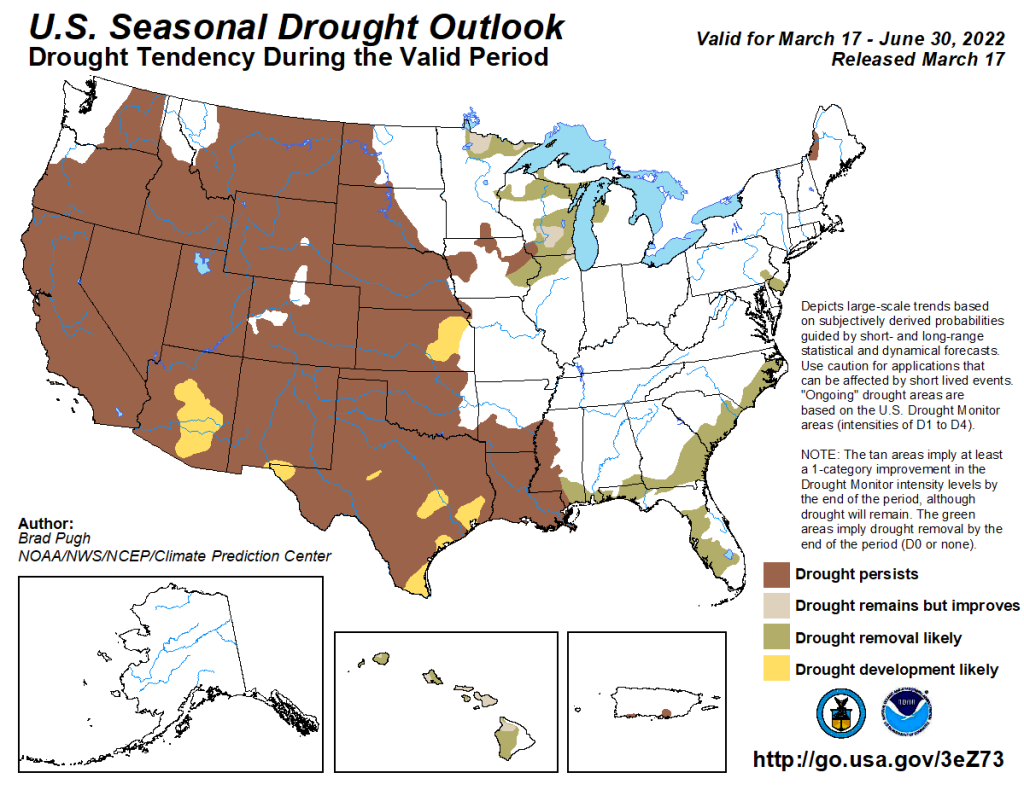
Last week the CPC released their drought outlook, which coincides with the spring season. Lots of brown…
Can We Expect A March Miracle?
Let me get this out of the way up front: No.
The driest January and February across two-thirds of the state has almost guaranteed that the deficit will be too hard to make up, even if we do get a “March Miracle.”
While San Diego County is not as bad off as the rest of the state, the prospects don’t look good for any of us in California.
It’s not looking like a March miracle will materialize. The drought needle will start redlining again this spring. Daniel Swain of UCLA explains why, in his Weather West blog: https://weatherwest.com/archives/13480
Winter Wonder
When will the rain and snow come back? Week after week, and it’s been about five weeks now since a respectable rain, the dry weather continues. It’s been a dry offshore pattern to be sure: a stationary ridge along the West Coast and shortwaves moving down the interior West one after another like a parade. Each wave boosts our offshore winds as we’ve seen every other day for a while now. The ridge shows no signs of moving through at least next weekend (2/12-13), but a look at this morning’s models show possibly, perhaps, maybe a shift in the longwave pattern that could nudge that ridge aside and open the door back up for winter storms. Yeah, we’ll see.
Daniel Swain of UCLA explains the longer term outlook. Not good through at least mid February. https://weatherwest.com/archives/12924

Rain lovers will get no love from Mother Nature through Valentine’s Day.
